Home>Garden Essentials>What Landscape Design Software Is Compatible With Google Earth?
Garden Essentials
What Landscape Design Software Is Compatible With Google Earth?
Modified: March 7, 2024
Looking for landscape design software that works with Google Earth? Discover the best garden-focused options to bring your outdoor vision to life!
(Many of the links in this article redirect to a specific reviewed product. Your purchase of these products through affiliate links helps to generate commission for Storables.com, at no extra cost. Learn more)
Introduction
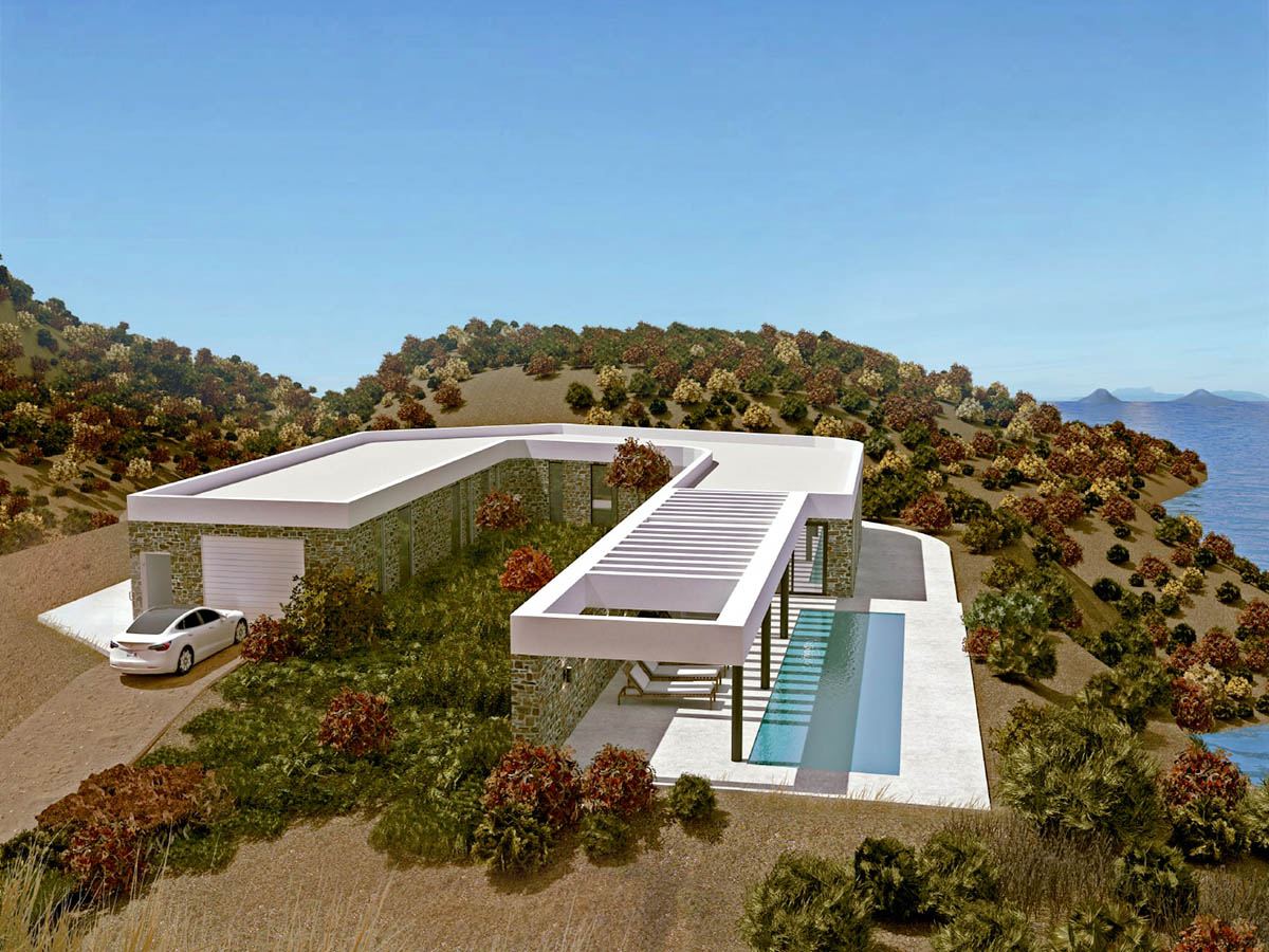
Welcome to the world of landscape design! Whether you’re a professional landscaper or a passionate gardening enthusiast, creating stunning outdoor spaces is undoubtedly a fulfilling endeavor. In this modern age, technology has revolutionized the way we approach landscape design, making it easier and more efficient than ever before. One such technological advancement is the integration of landscape design software with Google Earth, the popular virtual globe that allows users to explore our planet from the comfort of their homes.
Google Earth provides a detailed and interactive platform that offers a bird’s eye view of cities, landscapes, and even our own backyards. By combining the power of Google Earth with landscape design software, designers and homeowners can now visualize their outdoor projects in a three-dimensional space, allowing for greater accuracy and precision.
However, not all landscape design software is compatible with Google Earth. Finding the right software that seamlessly integrates with Google Earth is crucial to harnessing the full potential of these tools. In this article, we will explore the importance of compatibility and highlight some of the landscape design software options that work harmoniously with Google Earth.
Key Takeaways:
- Landscape design software that works with Google Earth allows designers to create 3D models and overlay them onto real satellite imagery, helping clients visualize and understand outdoor projects more effectively.
- Compatibility with Google Earth streamlines the design process, saves time, and enhances collaboration with clients, resulting in visually stunning and harmonious outdoor spaces.
Google Earth and Landscape Design
Google Earth is a powerful tool that provides a virtual representation of our planet through satellite imagery and aerial photography. It allows users to zoom in and out, rotate, and explore various locations with incredible detail. This technology has proven to be invaluable in the field of landscape design.
Landscape designers can utilize Google Earth to gather important information about a specific site. By zooming in and navigating around the desired location, they can assess the topography, evaluate the existing vegetation, and analyze the surrounding environment. This allows designers to understand the unique characteristics of the site and make informed decisions when designing outdoor spaces.
Furthermore, Google Earth provides designers with a realistic and immersive way to visualize their ideas. By incorporating landscape design software that is compatible with Google Earth, designers can create 3D models of their designs and overlay them onto the satellite imagery of the site. This not only helps in accurately positioning elements within the landscape but also allows clients to visualize and comprehend the proposed design more effectively.
In addition, Google Earth enables designers to explore different perspectives and viewpoints. They can analyze how sunlight and shadows interact with their design throughout the day, helping them make decisions about plant placement, hardscape materials, and more. This level of detail and realism empowers designers to create outdoor spaces that are not only aesthetically pleasing but also functional and in harmony with the environment.
With the integration of landscape design software, the possibilities become even more expansive. Designers can generate detailed plans and renderings, create virtual walkthroughs, and even simulate how the landscape will change and evolve over time. The synergy between Google Earth and landscape design software provides a comprehensive and integrated approach to visualizing and executing landscape design projects.
Importance of Compatibility
When it comes to choosing landscape design software, compatibility with Google Earth is an important factor to consider. Here’s why:
Seamless Integration: By selecting landscape design software that is compatible with Google Earth, designers can seamlessly transfer their designs to the virtual globe. This ensures that the design accurately aligns with the site’s topography and existing features, providing a realistic representation of the final outcome.
Enhanced Visualization: Compatibility with Google Earth allows designers to create 3D models that can be merged with the satellite imagery of the site. This integration provides clients and stakeholders with a more immersive and detailed visualization of the design proposal, helping them better comprehend the overall concept and its impact on the surrounding environment.
Accurate Site Analysis: With compatible landscape design software, designers can accurately analyze the site’s terrain, vegetation, and other existing elements. This information is crucial for making informed decisions about design elements such as grading, drainage, and plant selection. The ability to overlay design plans onto the site’s imagery allows for more precise planning and execution.
Efficiency and Time Savings: When landscape design software is compatible with Google Earth, designers can work more efficiently. The integration eliminates the need for manual data entry and simplifies the design process, resulting in considerable time savings. Moreover, changes and revisions can be easily made and updated in both the software and Google Earth, ensuring a streamlined workflow.
Client Collaboration: Compatibility with Google Earth facilitates better communication and collaboration with clients. Designers can showcase their ideas in a visually appealing and interactive manner, allowing clients to actively participate and provide valuable feedback. This collaborative approach fosters a stronger client-designer relationship and increases overall client satisfaction.
By selecting landscape design software that is compatible with Google Earth, designers can harness the full potential of these tools, ensure accurate representation of their designs, collaborate effectively with clients, and streamline their workflow. Now, let’s explore some of the landscape design software options that offer this compatibility.
Compatible Landscape Design Software
When it comes to landscape design software that is compatible with Google Earth, several options stand out. Let’s explore some of the top choices:
- Land F/X: Land F/X is a comprehensive landscape design software that seamlessly integrates with Google Earth. It offers a wide range of features, including plant libraries, hardscape creation tools, site analysis capabilities, and 3D modeling. With Land F/X, designers can easily transfer their designs to Google Earth, creating a cohesive and accurate representation of their projects.
- VizTerra: VizTerra is another powerful landscape design software that offers compatibility with Google Earth. This software allows designers to create stunning 3D visualizations and virtual walkthroughs of their designs. With its intuitive interface and extensive plant and material libraries, VizTerra provides a user-friendly experience while maintaining a high level of accuracy and realism.
- SketchUp: SketchUp, a popular 3D modeling software, also offers compatibility with Google Earth. While not specifically designed for landscape design, SketchUp provides a versatile platform for creating detailed 3D models of outdoor spaces. Its integration with Google Earth allows designers to overlay their designs onto the satellite imagery, providing a more immersive and contextual representation of their projects.
- DynaSCAPE Design: DynaSCAPE Design is a professional landscape design software that supports seamless integration with Google Earth. This software offers comprehensive tools for creating detailed site plans, 3D modeling, and accurate plant placement. With DynaSCAPE Design, designers can easily export their designs to Google Earth, enhancing the visualization and presentation of their projects.
- Pro Landscape: Pro Landscape is a feature-rich landscape design software that supports integration with Google Earth. It offers a vast library of plants, hardscape materials, and other design elements, allowing designers to create professional-looking landscapes. With Pro Landscape, designers can showcase their designs on Google Earth, providing clients with a realistic and immersive experience.
These landscape design software options provide seamless compatibility with Google Earth, enhancing the visualization, accuracy, and efficiency of landscape design projects. Designers can choose the software that best suits their specific needs and preferences while ensuring a smooth integration with Google Earth.
Land F/X
Land F/X is a comprehensive landscape design software that offers seamless compatibility with Google Earth. It is a highly popular choice among landscape professionals due to its robust features and user-friendly interface.
One of the key highlights of Land F/X is its extensive library of plants, hardscape materials, and other design elements. Designers can easily select and place these elements within their designs, creating accurate and visually appealing representations of their outdoor projects.
With Land F/X, designers can also perform detailed site analyses. The software integrates with Google Earth, allowing designers to import satellite imagery and overlay their designs onto the site. This integration enables them to assess the topography, evaluate existing vegetation, and analyze how their designs will interact with the surroundings.
In addition to site analysis, Land F/X provides tools for 3D modeling. Designers can create realistic and immersive visualizations of their designs, complete with textures, shadows, and lighting effects. The 3D models can be easily exported to Google Earth, providing clients with an engaging and interactive experience.
Furthermore, Land F/X offers features for irrigation design, including automatic scheduling and calculation tools. This allows designers to efficiently plan and implement irrigation systems that are both water-efficient and environmentally sustainable.
Collaboration is also made easy with Land F/X. Designers can easily share their designs and plans with clients, consultants, and other stakeholders. The software provides tools for generating professional-looking drawings and reports, ensuring clear communication and understanding among all parties involved.
Overall, Land F/X stands out as a top choice for landscape design software compatible with Google Earth. Its comprehensive features, user-friendly interface, and seamless integration make it an invaluable tool for designing and visualizing outdoor spaces.
One tip for finding landscape design software compatible with Google Earth is to look for programs that offer the ability to import and export KML or KMZ files, as these are the file formats used by Google Earth. This compatibility will allow you to easily transfer your designs between the software and Google Earth.
VizTerra
VizTerra is a powerful landscape design software that offers seamless compatibility with Google Earth. It is known for its intuitive interface and advanced visualization capabilities, making it a popular choice among both professional designers and homeowners.
One of the standout features of VizTerra is its ability to create stunning 3D visualizations of outdoor spaces. Designers can easily transform their 2D designs into immersive 3D models with realistic textures, lighting, and shadow effects. This allows clients to get a true sense of what their landscape will look like once it is installed.
VizTerra integrates seamlessly with Google Earth, enabling designers to overlay their designs onto the satellite imagery of the site. This integration provides a contextual and immersive representation of the design, helping clients better understand how it fits into the existing environment. Clients can explore the design from various angles, offering a more interactive and engaging experience.
In addition to its visualization capabilities, VizTerra offers a comprehensive set of tools for designing and planning outdoor spaces. The software provides access to a vast library of plants, trees, hardscape materials, and other design elements, allowing designers to easily select and place them within their designs. The software also includes features for modeling terrain, creating water features, and even simulating how the landscape will evolve over time.
Collaboration is made effortless with VizTerra. Designers can share their designs with clients through interactive presentations, making it easy to gather feedback and make revisions. The software also allows for the creation of detailed construction plans, helping in the smooth execution of the design once approved.
Whether designing a small residential garden or a large-scale outdoor project, VizTerra provides the tools and features necessary to bring designs to life. Its compatibility with Google Earth allows for an enhanced visualization experience, making it an excellent choice for landscape professionals and homeowners alike.
SketchUp
SketchUp is a versatile 3D modeling software that offers compatibility with Google Earth, making it a popular choice for landscape design projects. While not specifically designed for landscape design, SketchUp provides a flexible platform for creating detailed 3D models of outdoor spaces.
One of the key benefits of SketchUp is its user-friendly interface, which allows designers to quickly and easily create 3D models from their 2D designs. The software provides a variety of tools and features for modeling terrain, placing plants and trees, and designing hardscape elements. Designers can create accurate representations of their designs, complete with textures, colors, and even lighting effects.
SketchUp’s compatibility with Google Earth allows designers to overlay their designs onto the satellite imagery of the site. This integration provides a contextual and realistic representation of the design, helping clients visualize how it will look within the actual environment. Clients can explore the design from different angles, gaining a better understanding of how it fits into the landscape.
In addition to its 3D modeling capabilities, SketchUp offers an extensive library of pre-built 3D models, including furniture, accessories, and other design elements. Designers can easily incorporate these models into their designs, saving time and effort in the design process.
SketchUp also allows for easy collaboration and sharing of designs. Designers can export their models as 3D files, PDFs, or images, making it simple to present their designs to clients, contractors, or other stakeholders. The software also supports the integration of additional plugins and extensions, further expanding its functionality and customization options.
While SketchUp may require a bit of learning curve for beginners, its versatility and compatibility with Google Earth make it a valuable tool for landscape design. With its 3D modeling capabilities, ease of use, and seamless integration, SketchUp provides an effective platform for designing and visualizing outdoor spaces.
DynaSCAPE Design
DynaSCAPE Design is a professional landscape design software that offers seamless compatibility with Google Earth. It is widely recognized for its comprehensive set of tools and features specifically tailored for landscape design professionals.
One of the standout features of DynaSCAPE Design is its ability to create detailed site plans and 3D models. The software provides tools for accurate measurement, site analysis, and terrain modeling. Designers can easily incorporate site elements such as buildings, walkways, and vegetation, allowing for precise placement and visualization of the design.
DynaSCAPE Design seamlessly integrates with Google Earth, enabling designers to overlay their designs onto the satellite imagery of the site. This integration provides clients with a realistic and immersive view of how the design will appear in its actual location. The overlay allows clients to explore the design from different perspectives, improving their understanding of the final outcome.
In addition to its visualization capabilities, DynaSCAPE Design offers features for plant selection and management. The software includes an extensive plant library, complete with detailed information on growth characteristics and maintenance requirements. Designers can easily select and place plants within their designs, ensuring a cohesive and well-planned landscape.
DynaSCAPE Design also simplifies collaboration and communication with clients. The software allows designers to generate professional-looking presentations, complete with 2D drawings, 3D models, and even virtual walkthroughs. This enhances client engagement and enables designers to effectively convey their design concepts.
Furthermore, DynaSCAPE Design provides tools for generating detailed construction plans. Designers can create automated plant schedules, material lists, and cost estimates, streamlining the implementation process of the design. The software also allows for easy export and integration with other CAD and design software, facilitating a seamless workflow.
Overall, DynaSCAPE Design is a powerful landscape design software that seamlessly integrates with Google Earth. Its comprehensive set of tools, accurate site analysis, and enhanced visualization capabilities make it an excellent choice for landscape professionals looking to efficiently plan and execute their design projects.
Pro Landscape
Pro Landscape is a feature-rich landscape design software that offers seamless compatibility with Google Earth. It is widely recognized for its extensive library of design elements, user-friendly interface, and powerful visualization capabilities.
One of the standout features of Pro Landscape is its comprehensive library of plants, hardscape materials, and other design elements. The software provides access to thousands of high-quality images and detailed information on each item, allowing designers to easily select and place them within their designs. This extensive library ensures a wide range of choices and a visually appealing representation of the final design.
Pro Landscape seamlessly integrates with Google Earth, enabling designers to overlay their designs onto the satellite imagery of the site. This integration provides clients with a realistic and immersive view of how the design will look in its actual location. Clients can explore the design from different angles and perspectives, gaining a clear understanding of the spatial layout and visual impact.
In addition to its visualization capabilities, Pro Landscape offers tools for site analysis and measurements. Designers can analyze the topography, evaluate existing vegetation, and accurately measure distances and areas. This allows for precise placement of design elements and optimal utilization of the available space.
Pro Landscape also provides customization options, allowing designers to add personalized touches to their designs. The software supports the creation of custom plant libraries, the import of custom symbols and images, and the ability to create design templates, ensuring that each design reflects the individual style and preferences of the designer.
Collaboration and communication are made easy with Pro Landscape. Designers can generate detailed drawings, presentations, and even 3D walkthroughs to effectively present their designs to clients and stakeholders. The software also offers built-in estimating tools, helping designers create accurate cost estimates and material lists.
Overall, Pro Landscape is a comprehensive landscape design software that seamlessly integrates with Google Earth. Its extensive library, user-friendly interface, and powerful visualization capabilities make it an excellent choice for landscape professionals looking to create visually stunning designs and effectively communicate their concepts to clients.
Conclusion
The integration of landscape design software with Google Earth has revolutionized the way designers envision and execute outdoor projects. The ability to overlay designs onto satellite imagery provides a realistic and immersive experience, allowing clients to better comprehend the proposed designs in their actual context. The compatibility with Google Earth plays a crucial role in enhancing visualization, accuracy, efficiency, and collaboration in landscape design.
In this article, we explored several landscape design software options that offer seamless compatibility with Google Earth:
- Land F/X, with its extensive library and site analysis tools, provides designers with a comprehensive platform for creating accurate and visually appealing designs.
- VizTerra stands out for its advanced visualization capabilities and intuitive interface, making it a popular choice for immersive 3D visualizations and interactive presentations.
- SketchUp, while not specifically designed for landscape design, offers versatility and flexibility in creating detailed 3D models, making it a valuable tool for visualizing outdoor spaces.
- DynaSCAPE Design provides a comprehensive set of tools and features suitable for professional landscape designers, including detailed site plans, 3D models, and robust collaboration options.
- Pro Landscape impresses with its extensive library of design elements, user-friendly interface, and powerful visualization capabilities, making it a popular choice for landscape professionals.
The compatibility with Google Earth ensures that designers can seamlessly transfer their designs onto the virtual globe, accurately representing their vision and enabling clients to fully grasp the impact of the design on the surrounding environment. This integration improves communication, enhances client collaboration, and ultimately results in more successful and satisfying landscape design projects.
As landscape design continues to evolve, the compatibility between landscape design software and Google Earth will play an increasingly important role. By harnessing the power of these tools, designers can create visually stunning outdoor spaces that harmoniously blend with their surroundings, bringing their clients’ dreams to life.
Frequently Asked Questions about What Landscape Design Software Is Compatible With Google Earth?
Was this page helpful?
At Storables.com, we guarantee accurate and reliable information. Our content, validated by Expert Board Contributors, is crafted following stringent Editorial Policies. We're committed to providing you with well-researched, expert-backed insights for all your informational needs.


0 thoughts on “What Landscape Design Software Is Compatible With Google Earth?”