Articles
How To Use A Military Protractor
Modified: August 16, 2024
Learn how to effectively use a military protractor with our informative and detailed articles. Enhance your navigation skills and become a pro in no time!
(Many of the links in this article redirect to a specific reviewed product. Your purchase of these products through affiliate links helps to generate commission for Storables.com, at no extra cost. Learn more)
Introduction
When it comes to navigation and land surveying, having the right tools is essential. One such tool that is widely used by military personnel, hikers, and outdoor enthusiasts is the military protractor. A military protractor is a specialized navigational instrument that helps determine direction, measure angles, and plot routes on a map with precision.
In this article, we will guide you on how to use a military protractor effectively. By understanding its components and learning the step-by-step process, you will be able to utilize this tool confidently and accurately during your outdoor adventures or military operations.
Whether you are a beginner or already have some experience, this article will cover everything you need to know about using a military protractor. So, let’s dive in and explore the fascinating world of navigation with this indispensable tool!
Key Takeaways:
- Master the art of navigation with a military protractor by understanding its components, orienting it on a map, and measuring direction accurately for successful outdoor adventures or military operations.
- Utilize the military protractor as a valuable tool in your navigation toolkit, combining it with maps, compasses, and observational skills to confidently navigate diverse terrains and reach your destination with precision and efficiency.
Read also: 14 Amazing Military Protractor for 2025
Understanding the Military Protractor
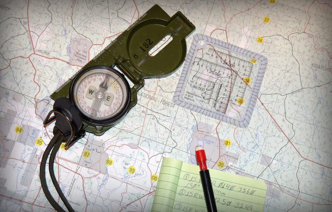
A military protractor is a compact, lightweight, and durable navigational instrument used for plotting routes, calculating distance and direction, and measuring angles on a map. It is specifically designed for military personnel, but it is also widely used by hikers, surveyors, and outdoor enthusiasts.
The military protractor consists of a transparent base with various markings and scales. It is typically made of high-quality plastic or acrylic material, which makes it both durable and easy to read. The protractor is designed to be used in tandem with a map, allowing users to accurately determine their position and plan their route.
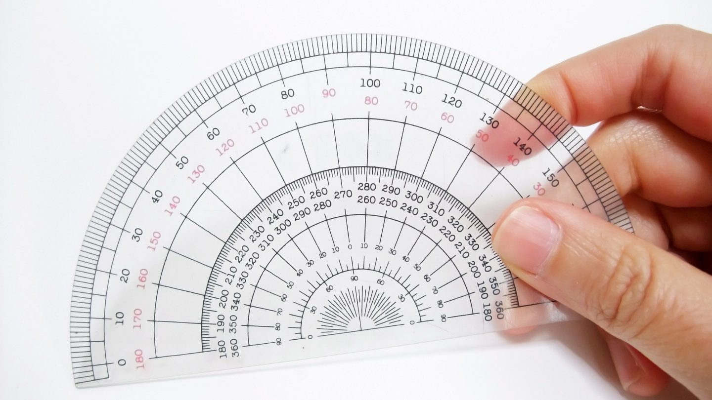
One of the key features of a military protractor is its ability to measure angles. It has a protractor scale that ranges from 0 to 360 degrees, allowing for precise measurements and calculations. This feature is especially useful when determining the direction of a landmark, plotting a course, or calculating the bearing between two points.
The military protractor also includes additional markings and scales that aid in navigation. These can include distance scales, conversion tables, and grid lines for precise map reading. Some protractors even have magnifying lenses and different units of measurement, such as millimeters and inches, to accommodate various types of maps.
Overall, understanding the components and features of a military protractor is crucial before delving into its practical applications. By familiarizing yourself with the protractor’s design and capabilities, you will be well-equipped to make the most of this invaluable navigational tool.
Step 1: Familiarizing Yourself with the Military Protractor
Before you can effectively use a military protractor, it’s important to become familiar with its various components and markings. This step-by-step guide will help you understand the essential elements of the protractor:
- Base: The base of the military protractor is typically transparent, allowing you to see the map underneath. It provides stability and a surface to place the protractor on the map.
- Edges: The protractor has two straight edges that extend from the base. These edges are used for aligning the protractor with the map and measuring angles.
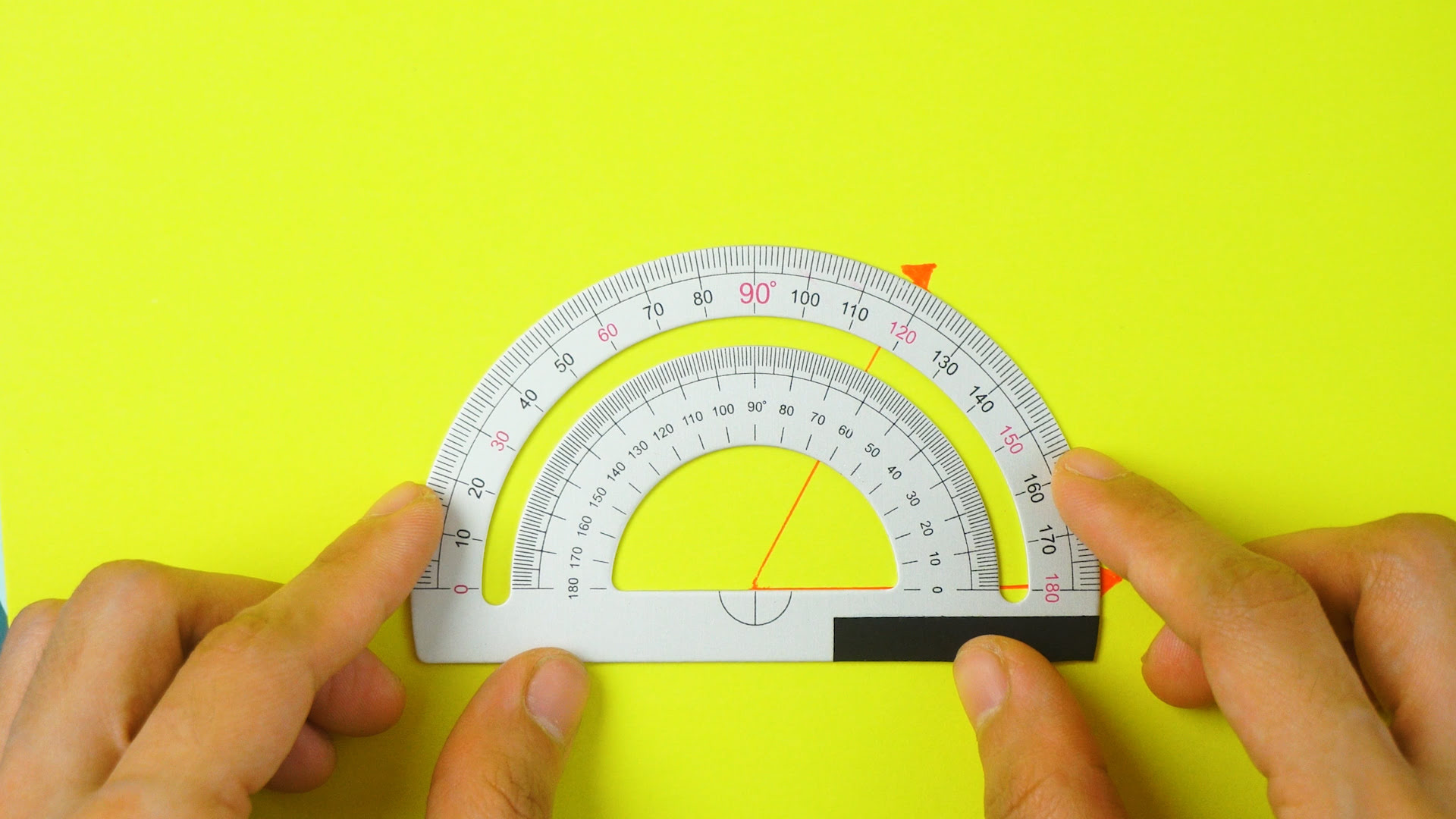
- Scale: The scale is the most crucial part of the protractor. It is a circular or semicircular line marked with degrees ranging from 0 to 360. This scale helps determine the direction and measure angles accurately.
- Arrow: The arrow, also known as the index line, is a prominent mark on the protractor. It points in the direction of movement or the reference point on the map.
- Orientation Lines: These lines run parallel to the base of the protractor and help align it properly with the grid lines on the map.
Take some time to handle the protractor, observe its various parts, and understand how they work together. This familiarity will make it easier to use the protractor effectively when you start practicing navigation techniques.
Additionally, it’s a good idea to read the user manual or guide that accompanies the military protractor. The manual will provide specific instructions and additional information about any specialized features of the protractor you are using.
By taking the time to familiarize yourself with the military protractor, you will have a solid foundation for using it accurately and confidently in the field. This understanding will make the subsequent steps much easier to comprehend and apply during your navigation tasks.
Step 2: Identifying the Different Components of the Protractor
Now that you are familiar with the overall structure of the military protractor, it’s time to delve deeper into its various components. Understanding these components will enable you to effectively utilize the protractor for navigation purposes.
- Protractor Scale: The protractor scale is the circular or semicircular line marked with degrees ranging from 0 to 360. This scale allows you to measure angles accurately. Each degree on the scale represents a specific angle, and it is essential to be familiar with these measurements.
- Index Line: The index line, also known as the arrow, is a prominent mark usually located at the center of the protractor scale. It points in the direction of movement or serves as a reference point on the map. Proper alignment of the index line is crucial for accurate measurements.
- Grid Lines: The military protractor may have grid lines printed on its transparent base. These lines are parallel and perpendicular to the protractor’s edges. They aid in aligning the protractor with the grid lines on the map, ensuring accurate readings.
- Distance Scales: Some military protractors also incorporate distance scales. These scales are used to measure distances on the map, allowing you to calculate the actual distance covered during navigation.
- Magnifying Lens: Certain protractor models may include a magnifying lens. This lens helps in reading small details on the map, such as grid values or contour lines, more easily.
- Units of Measurement: Military protractors may have multiple units of measurement, such as degrees, mils, or radians. Ensure you are aware of the unit being used and how to convert between different units, if necessary.
By identifying and understanding these different components of the military protractor, you will be equipped with the necessary knowledge to navigate accurately and effectively. Take the time to examine each component on your protractor and refer to the user manual or guide for additional instructions specific to your model.
With this knowledge in hand, you can now move on to the next step, where we will dive into understanding the scale and its significance on the military protractor.
Step 3: Understanding the Scale on the Protractor
The scale on the military protractor is a crucial component that allows you to accurately measure angles and determine direction. Understanding how the scale works is vital for effective navigation. Let’s explore the scale and its significance in more detail:
The protractor scale is a circular or semicircular line that is divided into 360 degrees. Each degree on the scale represents a specific angle measurement. It starts from 0 degrees at the top and goes clockwise all the way to 360 degrees, completing a full circle.
To measure an angle using the protractor, place the center of the protractor at the vertex of the angle, align the base line with one side of the angle, and read the degree value where the other side of the angle intersects the scale.
When using the protractor for navigation, it is essential to understand a few key concepts:
- True North versus Magnetic North: The protractor scale is usually calibrated to align with true north. However, in the field, you will often need to account for magnetic declination, which is the difference between true north and magnetic north. Make sure to adjust your readings accordingly.
- Bearing and Back Bearing: A bearing is the direction from one point to another, measured in degrees. The scale on the protractor helps you determine the bearing between two points on a map. The back bearing, on the other hand, is the opposite direction from the bearing.
- Azimuth: Azimuth is similar to bearing but is measured from 0 to 360 degrees clockwise from north. It is commonly used in military and surveying applications.
To get accurate readings, ensure that the protractor is aligned properly with the index line pointing in the intended direction.
Remember, the scale on the protractor allows you to measure angles, determine direction, and calculate bearings. Understanding how to read and use the scale effectively will greatly contribute to your accuracy and confidence in navigation tasks.
In the next step, we will explore how to orient the protractor on a map for precise navigation.
When using a military protractor, ensure that the center hole is aligned with the point of interest on the map. Then, use the protractor’s grid lines to determine the azimuth and measure the distance accurately.
Read also: 14 Amazing Map Protractor Military for 2025
Step 4: Orienting the Protractor on a Map
Orienting the military protractor on a map is a critical step in using it for accurate navigation. Proper orientation ensures that your readings and calculations align with the map’s grid lines and features. Let’s explore how to orient the protractor on a map effectively:
- Choose a Reference Point: Select a prominent feature on the map, such as a mountain peak, a building, or a large intersection. This will be your reference point for orientation.
- Place the Protractor on the Map: Lay the military protractor on the map with the index line pointing towards the reference point. Make sure the base of the protractor is aligned with the map’s grid lines.
- Align the Protractor’s Edges: Adjust the protractor so that its edges are parallel to the map’s grid lines. This ensures that your measurements and readings will be accurate and in line with the map’s orientation.
- Confirm Proper Alignment: Check that the index line is pointing towards the reference point and that the protractor’s edges are aligned with the map’s grid lines. Confirm this alignment by sighting a second reference point and ensuring that the protractor is aligned with both points.
Once you have successfully oriented the protractor on the map, you can proceed with using it for various navigation tasks. The proper alignment of the protractor will allow you to measure angles, determine bearings, and plot routes accurately.
It’s important to note that map orientation is crucial for accurate navigation. If the map’s north is not aligned with true north, you may need to consider magnetic declination and make adjustments accordingly. This is especially important in areas with significant magnetic variation.
By properly orienting the protractor on the map, you can ensure that your navigation calculations and measurements align with the map’s features. This will contribute to your overall accuracy and confidence in using the military protractor for navigation purposes.
In the next step, we will discuss how to determine the magnetic north using the military protractor.
Step 5: Determining the Magnetic North
Determining the magnetic north is crucial in navigation, as it helps you account for the difference between true north and magnetic north. This difference, known as magnetic declination, varies depending on your location and changes over time. To effectively navigate using a military protractor, you need to determine the magnetic north. Here’s how to do it:
- Consult a Compass or Magnetic Declination Map: Use a magnetic compass or refer to a map with magnetic declination information specific to your area. These resources provide the current magnetic declination value.
- Find the Declination Value: Determine the magnetic declination for your location and note if it is east or west of true north. Typically, the declination is given in degrees.
- Apply the Magnetic Declination: On your military protractor, locate the index line or arrow. Depending on your compass rose’s design, you may need to align the index line to either the true north or magnetic north indicator on the protractor.
- Adjust the Protractor: Rotate the protractor according to the magnetic declination value you obtained. If the magnetic declination is east, rotate the protractor clockwise by the corresponding number of degrees. If the magnetic declination is west, rotate the protractor counterclockwise by the corresponding number of degrees.
By applying the magnetic declination to your military protractor, you ensure that your navigational readings and calculations align with magnetic north, which is the reference point for most compasses.
It’s worth noting that magnetic declination values may change over time and can vary across different regions. Therefore, it’s essential to stay updated with the most recent declination values for your location.
Once you have correctly determined the magnetic north and adjusted your protractor accordingly, you can move on to the next step of using the protractor for navigation tasks.
In the next step, we will explore how to measure direction accurately using the military protractor.
Step 6: Measuring Direction
Measuring direction accurately is a fundamental aspect of navigation, and the military protractor is an excellent tool for this purpose. By following these steps, you can effectively measure direction using your military protractor:
- Identify the Starting and Ending Points: Determine the two points between which you want to measure the direction. This could be from your current location to a destination or between two notable landmarks on a map.
- Place the Protractor: Position the military protractor on the map so that the center point or index line is aligned with your starting point. Ensure the protractor’s edges are parallel to the direction of the intended path.
- Read the Direction: Look at the index line or arrow on the protractor and locate the degree value where it intersects the protractor’s scale. This is the measurement of the direction from your starting point.
- Convert to True North: If you adjusted for magnetic declination in the previous step, make sure to convert the measured direction to true north by adding or subtracting the magnetic declination value.
To read the direction accurately, be mindful of the alignment and placement of the protractor. Ensure that the index line is accurately pointing from the starting point to the desired direction. Additionally, double-check the alignment of the protractor’s edges with the map’s grid lines to avoid any errors in measurement.
Keep in mind that measuring direction is just one part of the navigation process. To plan a complete route, you will also need to consider distance, elevation changes, landmarks, and any obstacles along the way.
By effectively measuring direction using a military protractor, you can confidently establish your route and navigate towards your intended destination successfully.
In the final step, we will explore how to utilize the military protractor for navigation purposes.
Step 7: Using the Protractor for Navigation
Now that you have familiarized yourself with the military protractor, its components, and how to measure direction, it’s time to put it to practical use in actual navigation. Follow these steps to effectively use the protractor for navigation purposes:
- Select a Destination: Determine the specific location or point of interest you want to navigate to.
- Identify the Starting Point: Determine your current location or the point from which you will begin your navigation.
- Plot the Route: Using the military protractor, plot a straight line connecting the starting point to the destination. Ensure that the protractor’s index line is aligned with the intended direction of travel.
- Measure Distance: If your military protractor has distance scales, use them to measure the distance between the starting point and the destination. Alternatively, you can measure the distance using a ruler or other measuring tools.
- Consider Obstacles and Terrain: Take into account any obstacles, such as rivers, mountains, or dense vegetation, that may require adjustments to your route. Use the military protractor to assess the angle or bearing at which you need to navigate around these obstacles.
- Refer to Map and Compass: Combine the information obtained from the protractor with other navigation tools like a map and compass. Use the protractor to determine the bearing or azimuth to follow and cross-reference it with your compass readings and the map’s features.
- Monitor Progress: As you navigate towards your destination, periodically check your position on the map and adjust your route if necessary. Use the military protractor to reassess your direction and make any necessary corrections.
Remember to take into account any changes in terrain, environmental conditions, or any unexpected factors that may require adjustments to your navigation plan. Adaptability and flexibility are key skills in effective navigation.
By utilizing the military protractor for navigation, you can confidently follow your planned route, track your progress, and reach your desired destination with accuracy.
With the completion of this final step, you have learned how to effectively use a military protractor for navigation purposes. Whether you are navigating in the field, planning hiking routes, or participating in military operations, the military protractor will be an invaluable tool in your toolkit.
Remember to practice using the protractor in various scenarios and terrain types to enhance your proficiency and confidence in navigation. Happy navigating!
If you have any further questions or need additional guidance, refer to the user manual or seek advice from experienced navigators or military personnel.
Safe travels and successful navigation!
Read more: How To Use Bevel Protractor
Conclusion
Using a military protractor for navigation is a valuable skill that can greatly enhance your outdoor experiences or military operations. By familiarizing yourself with the components, understanding the scale, and mastering the step-by-step process, you can confidently measure angles, determine direction, and plot routes with accuracy.
We have covered the essential steps in effectively using a military protractor, from familiarizing yourself with its components to orienting it on a map, determining magnetic north, measuring direction, and utilizing it for navigation. Each step contributes to your overall ability to navigate with precision and confidence.
Remember, the military protractor is just one tool in your navigation toolkit. To navigate successfully, it’s important to also utilize other tools and references such as maps, compasses, and your observational skills. By combining these resources, you’ll be equipped to handle various navigational challenges in different environments.
Practice using the military protractor in different terrain types and scenarios to build your proficiency. As with any skill, continued practice and experience will improve your navigation abilities and help you become more efficient and accurate in using this valuable tool.
Whether you are hiking, backpacking, trail running, or engaging in military operations, the knowledge and skills gained from using a military protractor will empower you to navigate confidently and reach your destination successfully.
So grab your map, compass, and military protractor, and embark on your next adventure with the assurance that you possess the skills to navigate your way through any terrain or situation. Stay safe, stay prepared, and enjoy the journey!
Frequently Asked Questions about How To Use A Military Protractor
Was this page helpful?
At Storables.com, we guarantee accurate and reliable information. Our content, validated by Expert Board Contributors, is crafted following stringent Editorial Policies. We're committed to providing you with well-researched, expert-backed insights for all your informational needs.


0 thoughts on “How To Use A Military Protractor”